
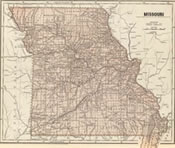
 Sullivan County is currently made up of 12 townships. Definition of a township is: A subdivision of a county in most northeast and Midwest U.S. states, having the status of a unit of local government with varying governmental powers. [3]
Note from Web Coordinator: The source of the original data was not provided. Some townships were not included but will be added as information is found. That added data will be provided. If information shown source is found, it will be added.
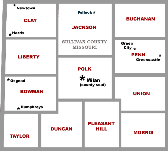
Below is a clickable map showing all townships. Data available only for Duncan, Jackson, Morris, Penn, and Polk townships.
Commencing where the ridge road on the divide between Main and East Locust creeks crosses the township dividing township 62 and 63, thence due west on the county line; thence south and east (this description should be south to the southwest corner of the county) with the county line to Main Locust creek; thence up said creek to the mouth of East Locust creek; thence north on the west side of the ridge road or divide between Main and East Locust creeks to the Indian Grave; thence north on the east side of said road to the place of beginning.
The place of voting was at the house of Isaac SCHROCK and the justice of the peace named was Robert BURNS.
On August 8, 1855, an order was entered of record as follows:
“It is ordered that Liberty township be subdivided as follows, to-wit:
'Commencing at the south line of said township where the same crosses
the main divide between Main and West Locust creeks; thence north
with said divide west of the residence of Wilson BALDRIDGE thence
north to the line between Sullivan and Putnam counties; thence east
along said county line to the section line dividing sections three
and four in range nineteen; thence due south with said line to the
center of township sixty-three (63), of range nineteen (19); thence
due west to the place of beginning. It is ordered that the territory [is]
bounded as above be known by the name of Jackson township and that
the precinct for voting be at the house of Branson JACKSON.”
Morris Township was named after the Robertson MORRIS family.
Commencing where the township line dividing townships 62 and 63 crosses the east line of the county; thence north and west on the county line to East Locust creek; (This description should be north to the north east corner of the county; thence west along the county line to East Locust Creek) thence down said creek to the middle of township 63; thence east to the main divide between East Locust and Yellow creeks; thence down said divide to the township line dividing township 62 and 63; thence east on said line to the beginning.
The house of Jefferson HUNSAKER was made the voting place, and at November term the county court, 1845, David VROOMAN was appointed justice of the peace. But the county court was not wholly satisfied with its judgement in the division of the county into townships and in August, 1847, created a new township out of a part of Duncan, defining its limits as follows:
“Commencing at the northwest corner of Duncan township; thence running east to the top of the main divide between West Locust, Medicine, Muddy and Parsons creeks; thence down said divide to the south line of the county; thence west and north with the county line to the beginning.”
This township was named after President Taylor. At the same term of court, the name of Vrooman township was changed to Penn township.
Commencing where Main Locust creek crosses the south line of the county; thence east to the main divide between East Locust and Yellow creek; thence north with said divide to a point two miles north of the township line dividing township 61 and 62; thence west on the section line to the ridge road running on the divide between Main and East Locust creeks; thence south on the east side of said road to the Indian Grave; thence south on the west side of said road to the forks of the creek; thence down Main Locust to the beginning.
Joeannah SEAMAN was appointed justice of the peace. William W. SEVIER's home was selected by the court as the voting place.
Commencing at a point on Main Locust creek two miles north of the township line dividing township 61 and 62; thence up said creek to the middle of township 63; thence east to the dividing ridge between East Locust and Yellow creek; thence down and divide to a point two miles north of the township lines dividing township 61 and 62; thence west to the place of beginning.
The party appointed by the county court as the peace officer of Polk township was Esam HANSON, and the place established for the electors to meet and exercise the right of suffrage was at the county seat of the county.
You may, of course, provide a link to this page in your database for the infomation shown. But the data was pulled from somewhere by a past coordinator, probably a county history book. Once found, it will be added.
How to Submit
» Use the “Contact the Site Coordinator” below and
place the word Township somewhere in the subject.

Volunteers working together to provide free genealogy websites for genealogical research. See these sites for more information or how to volunteer.
 Powered by FreeFind
Please . This site exists because of contributors like you.